▼ Cyclonic storm Mora hits Bengal bay [05-30-17]
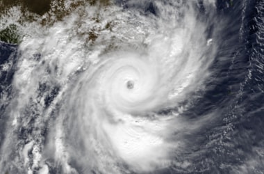 The cyclonic storm ‘MORA’ over east-central Bay of Bengal moved northward during past 06 hours with a speed of 11 kmph and lay centred at 0830 hrs IST, 29th May, 2017 over east-central Bay of Bengal near Latitude 17.3ºN and Longitude 91.3ºE, about 660 km south-southeast of Kolkata and 550 km south-southwest of Chittagong. The cyclonic storm ‘MORA’ over east-central Bay of Bengal moved northward during past 06 hours with a speed of 11 kmph and lay centred at 0830 hrs IST, 29th May, 2017 over east-central Bay of Bengal near Latitude 17.3ºN and Longitude 91.3ºE, about 660 km south-southeast of Kolkata and 550 km south-southwest of Chittagong.
The system is likely to intensify further into a severe cyclonic storm during next 12 hours. It is very likely to move north-northeastwards and cross Bangladesh coast between longitude 91.0ºE and 92.0ºE near Chittagong around 30th May 2017 forenoon.
Every year, the North Indian Ocean cyclone season extends roughly between April to December with two peaks in May and November.
This season includes cyclones in Bay of Bengal and Arabian sea, apart from Indian Ocean in northern hemisphere.
The first cyclone of 2017 season was Cyclone Maarutha which was formed in April, 2017 triggering heavy rainfall in Sri Lanka, Myanmar and India’s Andaman & Nicobar Islands.
Apart from other damages, three people were killed in Myanmar by Cyclone Maarutha. Cyclone Mora is second such cyclone in the Indian Ocean.
Naming of Tropical Cyclone Tropical cyclones are classified into three main groups, based on intensity: tropical depressions, tropical storms, and a third group of more intense storms, whose name depends on the region. If a tropical storm in the North-western Pacific reaches hurricane-strength winds on the Beaufort scale, it is referred to as a typhoon.
If a tropical storm passes the same benchmark in the Northeast Pacific Basin, or in the Atlantic, it is called a hurricane. Neither “hurricane” nor “typhoon” is used in either the Southern Hemisphere or the Indian Ocean.
In these basins, storms of tropical nature are referred to simply as “cyclones”.
|
▼ World's smallest republic Nauru joins ISA [05-24-17]
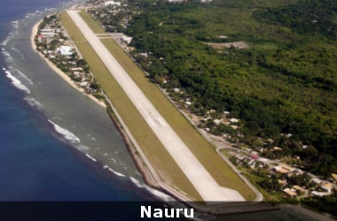 The tiny island of Nauru which is the world’s smallest republic has become the sixth country to ratify the International Solar Alliance (ISA) Framework pact. The tiny island of Nauru which is the world’s smallest republic has become the sixth country to ratify the International Solar Alliance (ISA) Framework pact.
Another five more nations namely the Comoros, Cote d’Ivoire, Somalia, Ghana and Djibouti have committed to ink the International Solar Alliance Framework Pact in the ongoing annual meeting of the African Development bank in Gandhinagar.
This is the first time that India is hosting the annual meetings of the AfDB and its sister institutions. India had joined the African Development Bank (AfDB) in 1983.
Nauru is a tiny island republic in Micronesia located in the northeast of Australia. Nauru has a population of 10,200-odd individuals.
The highest point in the island measures only 65 metres above sea level.
Hence, the island remains vulnerable to the adverse effects of climate change.
Nauru has a hot and humid climate and normally don’t experience cyclones.
Around 30% of the country’s power needs are met through solar power installations.
The tiny republic has set a target for attaining 50% of energy production from renewable sources by 2020.
ISA: Know More
- On the first day of the COP-21 summit, the International Solar Alliance was launched by Indian Prime Minister Narendra Modi and French President Francois Hollande.
- It is a union of countries with abundant sunlight.
- Under this alliance, 121 countries that fall within the tropics {i.e. between Tropic of Cancer and Tropic of Capricorn} have been invited to make collaborative efforts to harness solar energy to generate the electricity.
- Most of these countries are from Asia, Africa and South America.
- There are three objectives behind the International Solar Alliance.
- First is to force down prices by driving demand; second is to bring standardization in solar technologies and third is to foster research and development.
|
▼ MP government bans sand excavation in Narmada river [05-23-17]
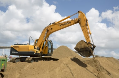 The State Government of Madhya Pradesh has put an indefinite ban on the sand excavation in the Narmada River. The State Government of Madhya Pradesh has put an indefinite ban on the sand excavation in the Narmada River.
This announcement has been made by Chief Minister Shivraj Singh Chouhan in Bhopal. The government has also set up a committee to suggest the scientific ways of mining the rivers.
This committee will submit the report to state government after exploring ways for sand excavation without harming rivers. The government will also promote manufactured sand (made by mixing stones).
Illegal sand mining is one of the serious law & order and environmental issues in several states of India including Madhya Pradesh.
The business has flourished mainly because of nexus between sand mafia, officers and politicians.
Many people including police officers and activists have lost their lives while making attempts to check this illegal activity.
The Chief Minister was has been travelling along side Narmada River to make “Save Narmada” a people’s movement through his “Namami Narmada Yatra”.
The issue of illegal mining in Narmada was sub-judice in state High Court but in July 2015, it was transferred to National Green Tribunal. On the basis of a complaint by Medha Patkar (of Narmada Bachao Aandolan), the NGT had sent a team to investigate the matter.
After investigation, NGT had directed state government to take strong measures and report the progress.
Narmada River: Know More
- Narmada (bringer of pleasure), is one of the largest rivers of India, originating in Amarkantak Hills and flowing through Madhya Pradesh, Gujarat and Maharashtra.
- It is third biggest river after Ganga and Godavari to flow within political boundaries of India.
- It flows in a rift valley between the Satpura and Vindhya Ranges; and serves as lifeline of Madhya Pradesh.
- Its basin covers large areas in the 3 states of Madhya Pradesh (86%), Gujarat (14%) and a smaller area (2%) in Maharashtra.
|
▼ Antarctica turns green due to climate change! [05-22-17]
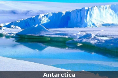 According to a new study conducted by a team of scientists from the University of Exeter in the UK, plant life on Antarctica is growing rapidly due to climate change. According to a new study conducted by a team of scientists from the University of Exeter in the UK, plant life on Antarctica is growing rapidly due to climate change.
The scientists have observed a sharp increase in biological activity in Antarctica in the last 50 years.
For ascertaining the growth, the scientists conducted tests at five cores from three sites and observed the occurrence of major biological changes across the Antarctic Peninsula.
The scientists made use of 150 years’ worth of data to arrive at the conclusion.
The study has been published in the journal Current Biology.
According to the scientists, Antarctica will be much greener in the future and the continent’s plants and soils will change substantially even with only modest further warming.
The continuous retreat of glaciers will make Antarctica much greener in the future.
As per the study, the growth of moss in the continent is a signifier that the region is already undergoing change.
At present, the plant life exists only in 0.3% of Antarctica.
With increase in land cover occurs decrease in snow and ice cover.
The thinner ice cover permits the penetration of sunlight into the previously dark areas allowing the planktons to grow.
This would bring ecosystem shift to Antarctica similar to what has happened in Arctic.
In March 2017, the US and European scientists had observed that the extent of sea ice at both poles has hit new record lows in this year’s season.
The disappearing sea ice comes as the Earth marks three consecutive years of record-breaking heat and temperature rise, raising fresh concerns about the accelerating pace of global warming.
Also, for the past two years, Antarctica saw record high sea ice extents and decades of moderate sea ice growth.
Recently, the researchers have also found that the Southern Antarctic Peninsula showed no signs of change up to 2009.
But after 2009, multiple glaciers along a vast coastal expanse suddenly started to shed ice into the ocean.
These glaciers measure around 750 km in length and are shrinking nearly at a constant rate of 60 cubic km and adding about 55 trillion litres of water each year.
With this level of shrinking, the region has become the second largest contributor to sea level rise in Antarctica causing small changes in the gravity field of the Earth.
Antarctica: Know More
- Antarctica, the southernmost continent and site of the South Pole, is a virtually uninhabited, ice-covered landmass.
- Most cruises to the continent visit the Antarctic Peninsula, which stretches toward South America. It’s known for the Lemaire Channel and Paradise Harbor, striking, iceberg-flanked passageways, and Port Lockroy, a former British research station turned museum.
- The peninsula’s isolated terrain also shelters rich wildlife, including many penguins.
- Area: 14 million km²
- Population: 5,000 temporary residents
|
▼ NGT bans ODF, waste dumping in Yamuna floodplains [05-22-17]
 The National Green Tribunal (NGT) on 19 May 2017 banned open defecation and dumping of waste on the floodplains of the Yamuna. The National Green Tribunal (NGT) on 19 May 2017 banned open defecation and dumping of waste on the floodplains of the Yamuna.
The tribunal also announced an environment compensation of INR 5000 for those who violated the diktat.
The ban was announced by NGT bench headed by NGT Chairperson Justice Swatanter Kumar while hearing a plea on monitoring the implementation of the ‘Maili se Nirmal Yamuna Revitalisation Project 2017’.
In addition to this, the bench also constituted a committee headed by Delhi Jal Board CEO to oversee the execution of work pertaining to the cleaning of the river and asked it to submit reports at regular intervals.
Besides, the bench also directed the Delhi government and the municipal corporations to immediately take action against industries which operate in residential areas and are a major source of pollution to the river.
Earlier on 1 May 21017, the apex green panel had ordered inspection of the STPs at Delhi Gate and Okhla with a view to ensuring that wastewater was cleaned before it reaches the Yamuna.
It had sought a report with regard to the functioning of these plants.
The tribunal was informed that a total of 14 STP projects are to be constructed to clean wastewater. Of these, seven are to be built by the Delhi Jal Board with its own funds.
|
▼ WMO announces 2017 as Year of Polar Prediction [05-19-17]
 The World Meteorological Organization (WMO) and the Helmholtz Centre for Polar and Marine Research (AWI) ON 15 May 2017 officially announced the start of the Year of Polar Prediction (YOPP). The World Meteorological Organization (WMO) and the Helmholtz Centre for Polar and Marine Research (AWI) ON 15 May 2017 officially announced the start of the Year of Polar Prediction (YOPP).
The Year of Polar Prediction (YOPP) is one of the key elements of the Polar Prediction Project.
The YOPP’s mission is to enable a significant improvement in environmental prediction capabilities for the polar regions and beyond.
It will be done by coordinating a period of intensive observing, modelling, verification, user-engagement and education activities.
YOPP also aims to improve verification of polar weather and environmental predictions to obtain quantitative knowledge on model performance, and on the skill of operational forecasting systems for user-relevant parameters; and efficiently monitor progress by World Meteorological Organization.
It seeks to improve understanding of the benefits of using existing prediction information and services in the polar regions, differentiated across the spectrum of user types and benefit areas and provide training opportunities to generate a sound knowledge base on polar prediction related issues.
WMO: Know More
- Abbreviation: WMO/OMM
- Formation: 23 March 1950
- Type: UN agency
- Legal status: Active
- Headquarters: Geneva, Switzerland,
- Head: Petteri Taalas (Secretary-General)
- Key Official: David Grimes (President)
- Website: public.wmo.int
|
▼ Elephant census begins in Karnataka [05-19-17]
 In Karnataka, a major exercise of elephant census began on 17 May 2017. In Karnataka, a major exercise of elephant census began on 17 May 2017.
The census exercise began simultaneously across all protected areas and forests of the state that were identified to harbour elephant population.
The Mysore Elephant Reserve, spread across 11,000 sq km through Bhadra-Nagarahole-Bandipur-BRT Wildlife Sanctuary, Cauvery Wildlife Reserve and Bannerghatta, harbours most of the elephants of Karnataka.
The last elephant census of Karnataka was held in the year 2012, which pegged the State elephant population at 6072 with Bandipur and Nagarahole accounting for nearly 1500 elephants each.
The census in Karnataka is a part of a Nationwide Elephant Census, which is being conducted to minimise possible errors.
Presently, the elephant census is being organized in all Southern States simultaneously. A similar exercise was held in eastern India last month.
Four states- Karnataka, Kerala (particularly the Western Ghat regions), Tamil Nadu and Andhra Pradesh account for 40 per cent of the country’s elephant population of more than 12000.
Elephant Census: Know More
- The Elephant Census is conducted every five years.
- Officially known as All India Synchronised Asian Elephant Population Estimation, the census covers all the forest divisions and protected areas where wild elephants are found.
- The nation-wide census is a three-month programme.
|
▼ Niti Aayog suggests 5 point remedy to tackle air pollution [05-3-17]
 Underlining air pollution as a serious problem, the government's think tank Niti Aayog in its latest action agenda has come out with a five-point remedy. Underlining air pollution as a serious problem, the government's think tank Niti Aayog in its latest action agenda has come out with a five-point remedy.
This is including higher taxes on petrol\diesel, higher parking fees and shutting down coal-based power plants in a phased manner, to deal with the menace within three years.
The Aayog suggested has already been in different phases of implementation under the government's plan of action, its emphasis may help states and central ministries to execute the measures on priority.
Listing coal-based power plants, brick kilns, vehicles (especially diesel), cooking and heating fires which burn biomass, waste burning, stubble burning and dust from construction, roads and fallow fields as “major sources of air pollution”, the Aayog noted that the problem is not limited to Delhi.
It wanted the government to take corrective action and strictly enforce various bans and traffic laws across the country.
The Aayog expressed its confidence that air pollution can be considerably reduced within three years through actions on the ground.
Suggesting higher taxes on petrol\diesel in and around polluted cities, the Aayog said the measure would encourage people to share cars and use public transport in bigger numbers.
It noted, the higher parking fees will have similar effect.
As far as stubble burning is concerned, the think-tank indicated that the crop residue burning is a very large contributor to air pollution in early winter in north India.
As productivity of wheat crop depends on early planting after rice is harvested, farmers burn residue in order to prepare the field quickly despite resulting pollution - as seen across farms in Punjab, Haryana and western UP.
The Aayog suggested use of ‘Happy Seeder' — a machine developed by the Commonwealth Scientific and Industrial Research Organisation, Australia and Punjab Agricultural University.
This allows planting of wheat through the residue.
In a section which elaborated on measures to deal with vehicular pollution in the cities, also proposed was a shift to electric vehicles in the long run.
The Aayog has also suggested regulation of polluting industries and disposal of solid waste and pitched for legislative route so that pollution control boards (PCBs) are empowered to “levy graduated fines” depending on the seriousness of the offence and on repeated offence.
|
▼ NOP rises and falls, in global warming paradox [05-2-17]
 Global warming may be inching the oceans higher every year but researchers studying the seas around India report a paradox. Global warming may be inching the oceans higher every year but researchers studying the seas around India report a paradox.
From 1993 to 2003 - the first decade when satellites started to consistently track the rise and fall of ocean heights and global temperatures soared - the North Indian Ocean (NIO) sea levels fell.
The NIO consists of the Arabian Sea, the Bay of Bengal and part of the Indian Ocean up till the 5°S latitude. After 2004, sea levels began an unprecedented, accelerated spike till 2014.
This rise and fall was even as global temperatures steadily climbed and registered their largest two-decadal jump in more than a century.
Previous studies that had measured ocean heights based on traditional tide gauges found that the NIO - like the rest of the world’s seas - continued to rise between 1993 and 2004.
While Intergovernmental Panel on Climate Change reports have concluded that while unabated greenhouse gas emissions into the atmosphere would cause oceans to rise every year, there would be years during which some seas could register a fall.
Scientists associated with the study said that such a “decadal swing” in the North Indian Ocean was unique and never observed in either the Pacific or Atlantic oceans.
The NIO went down about 0.3 mm a year and from 2004 gained about 6 mm annually. This was twice the global, annual average of about 3 mm.
When temperature and sea level trends in the NIO were mathematically separated out from the other oceans, the fall was even more dramatic: nearly 3 mm per year and the Arabian Sea cooling off rapidly at 4 mm per year.
Explanation for NIO Rise and Fall
- Sea levels primarily rise due to water expanding from atmospheric heat and, more water being added from, for instance, melting ice sheets and glaciers.
- 70% of the NIO’s warming could be explained by expansion.
- Unlike the Pacific and Atlantic, the NIO was hemmed in all sides, except for an outlet on the southern side.
- This influenced the rate at which heat was absorbed and flushed out from within the system.
- According to their calculations, heat was moving out slower during after 2004 than during the 1990s.
- The wind flows, which welled warm water on the Indian Ocean surface, changed directions every decade and probably influenced sea level patterns.
- It could be that coming decades - in spite of rapid, rising temperatures - will see a fall in sea levels but that’s still hypothetical.
|
▼ GoI to bring NTPC, power PSU thermal coal import to zero [05-2-17]
The government of India aims to bring down to “zero” thermal coal imports of power PSUs like NTPC in the current fiscal, a move that would reduce the country’s import bill by around INR 17,000 crore.
The government would also slowly convince the private companies operating in the power space to totally stop the import of thermal fossil fuel.
The company would want that coal import by these plants (of public sector companies) should be brought down to zero and slowly they would convince the private sector there is no need to import coal.
The government will also convince upon the private companies in the power sector to source coal through domestic sources as it is more reliable and prone to less price variations.
The move is likely to substantially bring down the country’s import bill. India will save around Rs 17,000 crore on import bill.
The Coal Ministry will make available to the power public sector units (PSUs) the supply of thermal coal through domestic sources in sufficient amount which would prompt the companies to not resort to import of fossil fuel.
|
| Chronology of events |
|
The first electric taxi trial in the country is going to be launched in Nagpur from 24 May, Union Transport Minister Nitin Gadkari said.
|


